
tongass national forest

Drought In The World’s Largest Temperate Rainforest?

Extreme drought in a rainforest might seem like an oxymoron, but it isn’t.

Since early 2018, the southern portion of Alaska’s Tongass National Forest, the largest intact temperate rainforest in the world, has experienced moderate to extreme drought. This has wide-ranging consequences on drinking water supplies, electricity costs, salmon habitat and forest health.

49 Historic Sites in the 49th State

This year America celebrates the 50th Anniversary of the National Historic Preservation Act. Alaska was still celebrating its first decade of statehood when the Preservation Act was passed by President Lyndon B. Johnson in 1966. Since then, the act has empowered the U.S. Forest Service to identify and preserve the state’s rich cultural history, including heritage sites that date back to time immemorial.

In honor of the 50th Anniversary, the 49 Sites in the 49th State website was developed by the Alaska Region and partners such as the State of Alaska, Native corporations and tribes, the National Park Service, and the Bureau of Land Management, and others to help state residents and out-of-state visitors explore. The site features many historical sites and treasures such as the Iditarod National Historic Trail, Lost Whaling Ships in the Bering Strait, and M/V Chugach ranger boat, the last of 10 Forest Service ranger boats that once plied the waters of the Tongass and Chugach national forests.

Alaska Beavers Entertain Web Cam Viewers Around the World

Two beavers sleep peacefully in their den on Steep Creek in Juneau, Alaska, never realizing they are being watched via a hidden infrared camera. Hundreds of viewers tune-in to a live video feed on the U.S. Forest Service YouTube Channel throughout the day to see the beavers come and go, breathing rhythmically as they nap and then stretch, chew and scratch an occasional itch.

Although the beaver cam is now an established fixture at the Mendenhall Glacier Visitor Center, it started out of simple curiosity according to Pete Schneider, a natural resource specialist for the Tongass National Forest. He and fisheries biologist Don Martin first experimented with a beaver cam in 2004 after they saw a cache of food in front of a beaver lodge on Steep Creek. It was a sure indication that beavers, who have a tendency to move around, were actually using the lodge at the time. They decided to run electricity through a conduit to that location in order to power an infrared camera.

Alaskan High School Students Learn Valuable Skills at "Fish Boot Camp"

This post was co-authored with Andrew Thoms, Executive Director of the Sitka Conservation Society.

“The thing that our forests grow best is salmon!” is the local phrase that a visitor is most likely to hear when visiting some of the 32 communities that live near the Tongass National Forest of Southeast Alaska. 

Tongass National Forest staff, local school districts, a local conservation organization, and the University of Alaska have undertaken a joint project to figure out how a forest can be managed to create jobs and other economic opportunities and guarantee the long-term sustainable yield of the Tongass’ fisheries resources.

Alaska's Newest Live Stream Salmon Cam Debuts

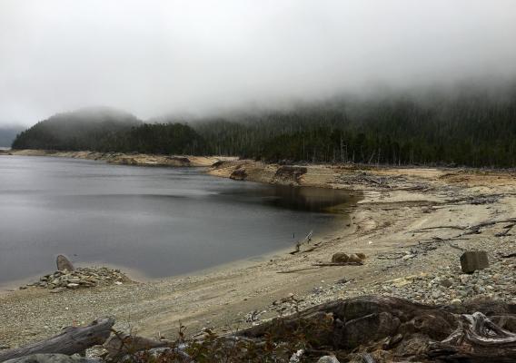
The City of Valdez, Alaska, offers a unique destination for visitors because of the proximity to the Crooked Creek Information Center, the most visited information center on the Chugach National Forest. Situated alongside the creek, a fish viewing platform beckons guests to take in the salmon returning to spawn each summer.

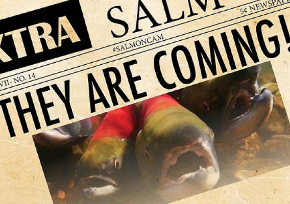
So what if you can’t make it to Alaska this summer? You can still experience the wonder through the Crooked Creek underwater fish cam.

An underwater camera has offered images of the swimming fish at Crooked Creek for several years; however, it was only linked to a monitor on the fish viewing platform. Visitors could get the bird’s-eye view of the creek from the platform, and then watch the fish underwater on the monitor. This summer, Andrew Morin, a fisheries biologist in Cordova, joined other Chugach employees to make the Crooked Creek fish cam available to the world via the Forest Service YouTube live streaming video.

Catch a Wild Alaskan Sockeye: Watch Live Stream as the Annual Homecoming Begins

An easy nine miles from the city of Juneau, a portion of a small non-glacial tributary creek nestled among alder, cottonwood and beds of dense, lush moss and understory vegetation is again sharing its ancient story of birth, death and renewal: sockeye and coho salmon are swimming home to spawn.

Yet visitors who want to take in this yearly natural story can view the wonder from the comfort of their own homes via a live online streaming from an underwater camera.

Cultivating Native Leaders in Conservation

Recently, ninety Alaska Native, American Indian, and Native Hawaiian high school students came together at the National Conservation Training Center in Shepherdstown, West Virginia for a week of intensive education and peer-to-peer training about the impact of climate change on tribal communities. Organized by the Inter-Tribal Youth Climate Leaders Congress and supported by a partnership between the U.S. Forest Service, the Department of Interior’s Bureau of Indian Affairs, U.S. Fish & Wildlife Service, the National Park Service, the U.S. Geological Survey, and the Environmental Protection Agency, the gathering included Jadelynn Akamu, Ylliana Hanato, Alisha Keli’i, and Aaron Knell from Honolulu’s Hawai’i Youth Conservation Corps and Forest Service partner KUPU, as well as a team from Juneau, Alaska, including Alaska Native student Sierra Ezrre and her mentor and culture keeper Carrie Sykes.

Tlingit Master Carver Restores a 74-year-old Totem in Alaska

In a small U.S. Forest Service workshop in Juneau, Alaska, a skilled Alaska Native artist is meticulously bringing a traditional artifact back to life. Tlingit Master Carver Wayne Price of Haines has begun the process of restoring the totem, which has overlooked the Auke Recreation Area near Juneau for more than 70 years.

In 1941, Frank St. Clair, a Tlingit from Hoonah, and two members of the Civilian Conservation Corps, originally carved the Yax té or Big Dipper totem, which symbolizes a “place where a strong tribe flourished.” The Aak’w Kwáan, according to historical documents, were Tlingit people and among the first to settle in the Juneau area.

Communities Connect with Nature on Alaska's Tongass National Forest

Scott Harris, the conservation science director for the Sitka Conservation Society, is on a mission. He’s dedicated to connecting the communities of Southeast Alaska to the stunning, natural world that surrounds them including the Tongass National Forest.

Sitka Conservation Society’s charge is to protect the forest’s natural environment while supporting sustainable development of surrounding Southeast Alaska communities. As director, Harris has worked for the last seven years to bring these communities together with those responsible for managing the landscape. The society and the forest partner together for work focused on ecological monitoring projects. For the past five years, they have worked with the Sitka Ranger District and local young students to monitor the effects of stream restoration projects. Harris has focused on increasing the number of interns in resource management during the past several years.

Southeast Alaska Trail Crew’s Work on Footbridge Links Generations, Cultures


On a boggy section of single-track trail outside the Southeast Alaska tribal community of Angoon, two men are building a bridge on Admiralty Island National Monument that does much more than simply cross 10 yards of boot-eating muck. This unassuming wooden span is connecting generations, cultures and governments while symbolizing a shared path forward for the Tongass National Forest and Southeast Alaska communities.

The bridge and trail are a vital link in the Cross Admiralty Canoe Route, a 32-mile series of lakes and trail portages that allows backcountry canoeists, kayakers and others to traverse the island. But while the Civilian Conservation Corps established the modern route in the 1930s, the path it follows was not news to the island’s residents, according to Donald Frank, tribal liaison for the national monument.