

The Forest Service is making it easier than ever to report the spread of insects that have invaded America’s national, state, private and urban forests.
Forest Health Protection has released Version 2 of its mapping and reporting portal. Built on the latest technology, the portal is an interactive and engaging complement to the agency’s Major Forest Insect and Disease Conditions annual reports.
The portal hosts a wide range of complex databases and provides public access to several web-based tools including:
- Forest Pest Conditions
- Data Summaries
- Insect and Disease Explorer
- Alien Forest Pest Explorer, and the Forest Disturbance Mapper.
“We’re excited to provide a variety of forest health information and products in one location,” said Patti Hirami, acting director of Forest Health Protection. “We hope our partners and clients will find this information useful as they work with us to improve the health of the nation’s forests.”
Forest Pest Conditions allow the user to explore county-level maps of major forest insect and disease conditions throughout the United States. The user can access an overview of biology, current conditions, trends and survey methods, as well as photos and web links for each forest insect and disease in the database.
Using the Data Summaries interface, the user can review, query and download tabular data for all forest insects and diseases recorded through aerial surveys in the U.S. since 1997. With the Insect and Disease Explorer, geospatial data can be downloaded and printed.
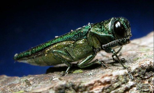
The Alien Forest Pest Explorer is a tool for generating and exporting reports on the biology of non-native forest insects and diseases, such as emerald ash borer and white pine blister rust. Maps at state and county level of their physical locations are available..
The Forest Disturbance Mapper is an interactive application that provides the user with access to satellite-based, remotely sensed data used to detect forest damage at the landscape level. The principal user is a person who plans regional or statewide flight planning for aerial pest surveys. The application can help lower costs for aerial surveys by allowing users to explore remotely sensed areas of interest online prior to flight, and plan flights accordingly.