


Yellow-cedar is an ecologically, culturally, and economically important tree species in the coastal temperate rainforests of Alaska and British Columbia. This slow-growing tree has few natural insect and disease agents and is capable of living more than 1000 years.
But less snow in Alaska’s winters is leading to the demise of yellow cedar trees at and just above sea level. During hard freezes when little or no snow is on the ground to insulate the yellow cedar’s shallow roots, the roots freeze. Ultimately this leads to the tree’s death. This yellow cedar decline has occurred over the past 100 years.
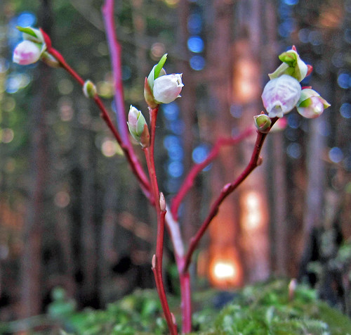
This winter here has been particularly warm. At sea level, rain rather than snow has dominated the precipitation. Instead of crisp, snowy winter days, we’re experiencing soggy, drippy weather. The temperature is warm enough that the early blueberries are beginning to flower. Because this is very early for flowering, a hard freeze later in the winter could destroy the budding plants and threaten the berry crop.
Winters in southeastern Alaska and the Tongass National Forest are typically heralded by a series of storm systems that roll in from the west, often remnants of collapsing typhoons that originate in the tropics and carry a large amount of moisture. These storms are in part responsible for our glaciated landscape and temperate rainforest, and the wind disturbance ecology on both small and large scales.
As soon as the storms hit the Alaska coast and mountains, the air lifts, cools and then a supercharge of precipitation drops rain at low elevations and snow higher up. These storms often retain their cyclonic form and can generate hurricane force winds.
This year the big weather systems tended to arrive in Alaska further to the west than usual, sparing the southeastern portion of the state its usual scary storms.
Normally in January and February we have three or so periods of clear, cold weather. However, this year we experienced that clear, relatively cold weather in November. Some have characterized this mild weather as a “Puget Sound” winter.
What are the current winter conditions? Live views of weather throughout Alaska are available on the Federal Aviation Administration’s website of Alaska airport cameras. On this website you can also see views of Tongass and Chugach National Forest lands.
Mary Stensvold is the regional botanist in the Forest Service’s Alaska Region.
