

Access to stores that carry healthy, affordable food can play an important role in people’s nutrition and overall health. Ensuring access to healthy food is a priority for USDA and a key component of First Lady Michelle Obama’s Let’s Move! initiative.
Two years ago, USDA’s Economic Research Service (ERS) first released the Food Desert Locator, an online mapping tool that used the 2000 Census and other data sets to identify low-income census tracts in which a substantial number or share of residents face challenges in accessing the nearest supermarket or large grocery store. My ERS colleagues and I have now updated and expanded the tool and renamed it the Food Access Research Atlas.
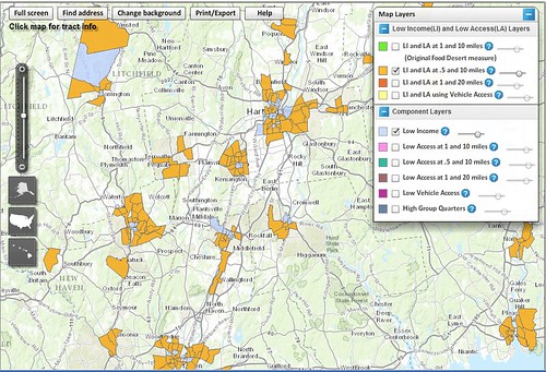
The new name better reflects what this tool shows us. Now, the Food Access Research Atlas has updated estimates of food desert census tracts using 2010 census data, and offers several additional distance measures to visualize access to supermarkets. For example, in the original measure, a household was considered to be facing an access challenge if it was more than 1 mile from a supermarket in urban areas of the country or more than 10 miles from a supermarket in rural areas. With the updated Atlas, users can also map low-income and low-access areas using distances of one-half mile and 20 miles.
In addition to expanded data layers for distance, the updated Atlas also highlights the role of vehicle availability in mitigating the difficulties of reaching a supermarket by identifying census tracts where many households lack access to a vehicle. Knowing where people face low access to both supermarkets and vehicles can be a first step toward addressing the most acute access challenges.
Another new feature identifies census tracts where a large proportion of the population lives in dormitories, military quarters, or similar group living arrangements as defined by the Census. While individuals in these census tracts may be far from a supermarket or large grocery store, such facilities frequently provide dining facilities or food stores for their residents. Noting these census tracts may provide a more accurate picture of whether these residents truly experience difficulty accessing affordable and healthy food.
Through these additional measures, updated data, and added layers of detail, the Food Access Research Atlas builds on past research to provide researchers, city planners, non-profit organizations, and policymakers at all levels a more nuanced view of the factors that impact whether people across the country can attain nutritious and varied diets. Check out the Food Access Research Atlas and discover what’s new!