

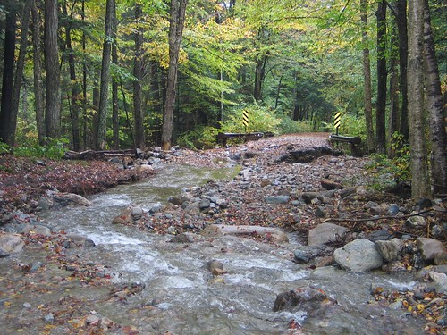
Remember the devastating floods in Vermont – the worst in a century – that made national headlines late last August? Hurricane Irene pounded Vermont and the Green Mountain National Forest and New Hampshire and the White Mountain National Forest with up to 12 inches of rain in less than a day. Many communities were left reeling from the massive flood damage for weeks and months in post-storm recovery efforts.
More than 500 road miles and 200 bridges and culverts were destroyed or damaged. Communities were left stranded by the flood’s devastation of the transportation infrastructure. Millions of dollars of property damage occurred. Residents also suffered increased costs related to emergency service access, commuting time and lost tourism revenue. Aquatic life was also harmed when heavy machinery cleared “debris” and reshaped rivers.
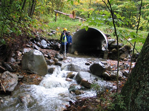
Now, a success story on the Green Mountain National Forest offers help and hope to communities in preventing road and bridge washouts and environmental damage. Forest Service technical experts who assessed the storm’s impact on the forest found flood damage at stream crossings with undersized culverts, as well as roads following stream banks and in natural areas of sediment deposition like alluvial fans. However, culverts that had been recently replaced using an agency scientific method known as the Stream Simulation Design Approach suffered no damage and safely passed huge volumes of water, gravel and trees that clogged and destroyed other traditional culverts in the area.
The approach examines hydraulics, engineering and river processes to design a natural channel underneath a road crossing that simulates the natural stream’s characteristics and functions. Stream simulation channels are designed to adjust laterally and vertically to a wide range of floods and handle a variety of gravel and wood without inhibiting fish and other aquatic organisms from moving up or downstream. While initial installation costs range from 30 to 70 percent more than traditional culvert approaches, long term costs are significantly reduced as the culverts survive large floods and function virtually maintenance free.
Both the Green Mountain and White Mountain National Forests are now partnering with their states, communities and non-governmental organizations such as Trout Unlimited and White River Partnership to use the approach to help communities avoid future flooding threats to ensure both habitat protection and unnecessary economic disruption.