


There are few better ways to plan your get away on a national forests or grasslands than to use the Forest Service’s online Visitor Map. With thousands of recreation areas, roads and an increasing number of trail systems, you can digitally explore and plan your next adventure from home before you even hit the road.
With recently updated features, finding the perfect forest or grassland location is easier than ever.
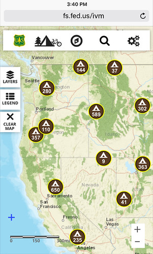
And it’s as easy to use. For instance, when the online visitor’s map first displays, an area called Explore is shown where you can select one of six items from its menu, with camping or hiking being the most popular. But selecting any of these items brings up clusters where these activities exist and by clicking each cluster, you can further zoom into the map as far as you’d like.
The site has additional features that the Forest Service thinks you’ll really enjoy. First, you can share your outdoor experiences with us or anyone else for that matter on a social media app called Yonder.
The creators of Yonder describe the app as a “…purpose-built for sharing your camping vista, red point, single-track descent, pow shot, or dawn patrol adventure with a community that’s just as psyched about the outdoors as you are.“
We agree. So, when you’re out exploring on your public lands, we really encourage you to share your photos and videos! Just remember, reservations are required at many campgrounds, so a link is provided in the info window where the reservation can be made at recreation.gov.
Another cool feature allows Forest Service twitter content to be geo-located on the Visitor Map. Geo-location helps us get important messages out to you. So, don’t forget to look for our Tweets on the map near the areas that interested you.
Even though we have lots of features and areas to explore using the Visitor Map we are always looking to improve our Forest Service Web-based products. So give it a try and let us know what you think.